| Just after crossing into Louisiana
Map of Louisiana
Welcome Centers
Map
of Louisiana
Maps
of sections of Louisiana & certain cities
Maps
of large US areas
search.=Maps
Louisiana
State general info:
http://www.state.la.us/
http://www.crt.state.la.us/crt/tourism.htm
State Parks: Louisiana State
Parks Map La.State
Parks web page
US Wildlife Refuge: http://www.fws.gov/~r4eao
Commercial Info: http://www.louisianatravel.com/index.html
we headed south-west and to our surprise we found ourself's in mile
after mile of rolling hills covered with a pretty pine forest. For
many days and miles to come we would feel like we were in Oregon, only
without the cold damp... Now remember this is Louisiana cool
April. As it would turn out our entire time on this trip would have mostly
nice moderately warm day (81*) and cool sleeping nights.
Driving west and south we camped at EK Long state
park. Then on to Natchitoches, the oldest established
city in Louisiana. A river runs through the center of a well kept old down-town.
Many restored buildings. There is a large college in the city and we found
a GOOD Chinese restaurant.
That night we stayed in a US Forest Service campground,
6 miles of dirt road.
I would not do that again, even though it was on the banks of a beautifully
clear running and swim-able bayou-creek in a national forest just south
west of Natchitoches.
The next day we found our self on the Toledo
Bend Reservoir. It's the 5th largest man-made lake in the US. It is
located on the Louisiana - Texas state line. Surprisingly
enough, we were still in pine forest and rolling hills.
From here south Louisiana turns into prairie
land and dissolves slowly into bayou's, marshes and swamps.
I'm talking about the lower 1/3 of Louisiana.
We stayed at a Army family-camp on the lake for two days.
I found and reinstalled a helper-spring
on the passenger side rear axle and then I enjoyed a rest and watching
the stars-constellations at night. Sue enjoyed a fellow campers
wife(crafts person) and the heavy but short-lasting thunder storm
that dumped tones of rain water directly into the center of the inside
of the motor home.
After the storm passed I checked the swamp-cooler on the roof and found
that the 2 * 2 1/2 foot cover was gone. O-boy another improvisation
project for Dale.
After things cleared up we headed south-east to
Lake Chicot state park, just north of the town of Villa Plat,
the start of Cajun country .
http://www.louisianatravel.com/family_fun/congres_mondial/index.html
http://www.nps.gov/jela/
http://www.crt.state.la.us/crt/tourism/maps/getmap.htm
This is a small town on the north edge of the Louisiana prairie. Cajuns
were one of the main groups of settlers to this area. The links above will
give you further details of their interesting history and culture! Take
some time to look them over. Their influence in the state is renound;
their food, their music, their fun loving spirit and warmth, all enhanced
by a vibrant history.
http://www.crt.state.la.us/crt/cajuncon
This link has a sound file, and
the one below holds the rest of the active musical activity in Louisiana.
http://www.crt.state.la.us/crt/tourism/music/musictr.htm
After spending a few days in Villa Plat we went south to
Lafayette
http://www.crt.state.la.us/crt/tourism/maps/inlaf.gif
and the annual week long music celebration Cajun,
Zidego, African, French-Canadian, Rock & Roll, Fiddle & Guitar
pick-en, and Gospel groups. All performing
on the up to five continuous-activity stages....ALL for FREE. You can bet
we stayed in the city campground ($9 a night). The parking was even free.
Although we left Angie in the motor home most of the time she did
get to listen to the music and crowds; and partake of the food; Craw-fish,
Gumbo, Shrimp, Jumbolia, and you name it. I
almost forgot to mention that the motor home had $480
of spring work done while in town.
After that wonderful week we headed further southeast to St.Martinville
where the Live-Oak stands by the bayou where lovers came together in the
famous poem "Evangeline" .
The story is about a Arcadian man and women who were separated in
Canada and many years later found each other. When the girl came down the
bayou on a riverboat only to find her long lost lover standing on the dock
with his wife and child. Her heart was broken on the spot. After visiting
with a couple of brothers that have been playing for visitors at the oak
for twenty years and were feathered in national publications, we headed
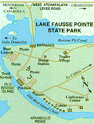
for the Lake Fausse Point State Park on the Levee Road about 18 miles from
town and deep in the central Louisiana Bayou country. Park
Map
Houma was our nest destination. It is in the Cajun
heartland. We camped for $10 a night just 5 minutes from down
down. We visited the local visitor center and found out where Cajun
food was served and dances were held. While staying there we
traveled in the local area going up one bayou then down another. We even
tried a swamp tour, which we found interesting but not necessary after
all the excursions we have been on..
http://www.louisianaswamp.com/
This just an example and not the tour we took.
New Orleans http://www.crt.state.la.us/crt/tourism/maps/inno.gif
What can I say? We stayed on the Navy Base in Algiers, just
across the Mississippi River from downtown and the French Quarter.
Each morning we would catch a bus, either to the ferry to downtown or ride
across the bridge and get off just three blocks from the French Quarter.
If you haven't been to New Orleans you might not know that this is the
section of town where it happens.
The section is 15 to 20 blocks long and 8 blocks wide, resting on the
north side of a very sharp bend in the Mississippi river. Just 80 miles
from the Gulf of Mexico.
We took the obligatory ride on a river paddle wheel steamer,
The Natchez. I is a reconstruction but has a old time steam boiler
and steam driven rams pushing the paddles round and round. The engine room
is open during the two hour cruise down the Mississippi River and it is
a must see!
One lunch our we spent at Arnold's,
a old time grand restaurant. After our $50 lunch the head waiter asked
if we would like to see the Mardi Gras museum that the restaurant maintains
on the premises for special diners. We were very honored. As it turns
out the Lady the owned the restaurant were known as the Queen of theMardi
Gras for 25 years, serving as the Queen for that period. The museum
holds many pictures and many of her beautiful gowns.
After lunch we rode the famous trolley to
the Garden district and walked the area taking in an old time cemetery
and many blocks of marvelous mansions. While hi style still exists
in the area, I'm sorry to say the the area around the district has fall-in
into deep decay and threatens the continuing tranquility of the grand homes.
We were told that the French-Creos that ran the French Quarter didn't desire
to live with the German's they had brought in to grow the vegetable crops
and so this community arose from the prospering gardener class.
Next destination; Saint Bernard, Louisiana.
on the east side of the Mississippi river about 25 miles south of
New Orleans. It is basically the north turning point in our journey and
sports a population of Canary Island residence that the Spanish
government encouraged and sponsored their move when the Spanish owned
the territory that the US later purchased as the New Orleans Purchase
from France.
|