I am particularly pleased with this editorial in the Palos Verdes Peninsula News. Although outnumbered on the City Council 4 to 1, I led the effort to make sure that before the city allowed building in the landslide moratorium zone, the geological analysis undertaken for the city used the scientifically accepted geological standard.
Instead of asking the geologists to apply the only scientifically accepted standard, the city council was close to opening the landslide area to building based on an analysis that asked whether building would "make the landslide worse." Such an analysis would have allowed building on land that was moving, simply because the geologists told us that allowing a particular building would "not make the landslide worse!"
I pursued the analysis, questioned the "not make the landslide worse" standard, sought additional information from the geologists, and in the end the full city council supported my proposed Resolution rejecting the previously proposed "not make it worse" standard. Instead, the city adopted the accepted geological standard demanding a factor of safety of 1.5. While this result may seem obvious, both then Mayor Marilyn Lyon and Mayor Pro Tem John McTaggart had signed an August 21, 2002 report requesting that the city council start the process to allow building under that unacceptable "not make the landslide worse" standard.
Click this text to read the Cotton Shires Geotechnical analysis.

If, in the past, Rancho Palos Verdes council members have given the impression that building atop the Portuguese Bend Landslide Complex is safe, today's council has an entirely different opinion.
For that, residents should be thankful. Today's council has replaced foolhardy optimism with caution, a prudent attitude given the unknowns that surround the area's geological conditions.
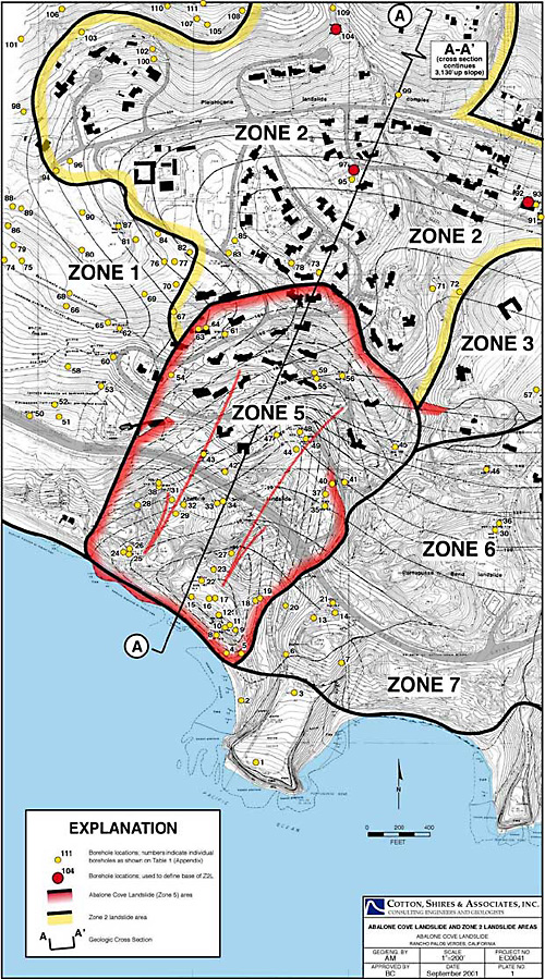
One might remember last spring's battle with residents who own empty lots in Portuguese Bend's Zone 2. Those residents were given the impression by past councils that someday - many believed sooner than later - they would have the ability to construct dream homes in this quiet, private coastal neighborhood. In fact, the building moratorium that overlays a vast majority of the region was put in place as a temporary restraining device, not to be lifted until the relationship between construction and land movement was better understood.
According to geologists who have studied the area for decades, that relationship is still unknown, despite the millions of dollars that city officials have poured into research. It is also unknown how well a new sewer system will benefit Portuguese Bend, most of which continues on a steady course toward the Pacific Ocean, albeit at a snail's pace. Another mitigating project, one to line Alta Mira Canyon, the area's primary drainage channel, appears to have stalled for lack of funding. If the area is any safer now than it was in the 1970s, when landslides cause significant damage to Portuguese Bend, there is no substantial proof.
Last week, council members placed more limits on construction by restricting addition sizes proposed for existing homes within the landslide moratorium to 600 square feet. Though the position council took may prove unpopular it was both wise and fair. Common sense tells us that one does not approach landslides with a "do-it-and-see-what-happens" attitude.
Some argued that the 600 square-foot limit was not based on scientific evidence. That is true. But, as we have realized from past I experiences - Ocean Trails, anyone? - the empirical means of supplying such evidence is flawed. The saying around town that geology is as much an art as it is science is sad but true.
The building limitation is as much for the council and community's peace of mind as anything else. Past councils continuously loosened restrictions on additions from the original 250-square-foot limit to just about any size, give city approval. Those council members knew less about the landslide than today's representatives, and the fact that no major slide has occurred is due more to luck than expertise.
The Peninsula News continues its support of the RPV City Council in dealing with these tough issues. Council members job is looking out for the safety of the entire community, even if it means current residents don't get everything they dream of.